

Setup & config options
Suitable power supply
RasPi & sFTP file transfer
Home network print server
Home network scan server
Mesh : home Lan USB drive
Explore hard & software
UFW firewall explained
Secured by fail2ban server
Software packaging & PPA
Apache 2.4+ LAMP server
https web server : port 443
Varnish caching proxy
Module : cgi & perl
Module : geoip
Modules : php & mysql
http*s error handling
Server : conditional logging
TL-domain & dynamic DNS
Webalizer log analyser
Defeat referrer spam
robots.txt & xml sitemaps
Server : .htaccess handling
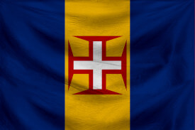
The game & not the islands
Setup & config options
North Atlantic : Macaronésia
🚫 No ads & tracking
![]()
![]()
![]()
![]()
![]()
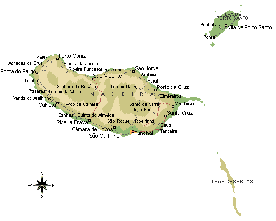
The Madeiran archipelago
An interesting snapshot on Madeira, Porto Santo and the Ihlas Desertas
This is an older article which I wrote on a free subdomain provided by Wordpress many years ago.
14-Jul 2018
Madeira is an island of astonishing contrasts. From the big-city sophistication of the capital, Funchal, it is a short step to the primeval woodland that cloaks the dramatic cliffs and canyons of the island’s interior. The fertility of Madeira’s flower-filled gardens is in marked contrast to the aridity of the island’s volcanic peaks. And nothing could be more different than the gentle rippling of the levadas (canals), which carry water into Madeira’s deepest valleys, and the crash of the waves that dash the island’s rocky shores. Madeira has been called a place where all the continents meet. It has something of them all – including snow.
Hewn out of the island’s volcanic rock and its abundant timber supplies, Madeira’s cathedral is a monument to the faith and piety of the island’s first settlers. Trade contacts with Antwerp in the 15th century enabled Madeira’s merchants to sell their sugar – so valuable that it was known as “white gold” – and buy the superb Flemish paintings and sculptures that fill this art museum.
Madeira is renowned for its wines, famous for their complexity and depth of flavour. At this historic wine lodge you can sample different vintages and learn to be a Madeira connoisseur.
- Museu da Quinta das Cruzes, Funchal: Look inside a gracious Madeiran mansion, built on the site where the island’s first ruler, João Gonçalves Zarco, had his home.
- Jardim Botânico, Funchal: The Botanical Gardens are a showcase for all the plants that thrive in the island’s warm and humid climate, from jungle orchids to bristling cacti.
- Mercado dos Lavradores, Funchal: The Farmers’ Market is a bustling medley of colourful stalls positively bursting with exotic fruits, scented flowers and examples of local crafts.
- Quinta do Palheiro Ferreiro: Two hundred years of cultivation have produced this magnificent all-seasons garden where the flowers of the world combine with the English flair for garden design.
- Monte: Escape to a romantic world of gardens, tea-houses and cobbled walks, home to Emperor Charles I in exile. Afterwards, return to the capital on the exhilarating Monte toboggan run.
- Curral das Freiras: During pirate attacks, the nuns of Santa Clara took refuge in this hidden green valley encircled by sheer cliffs – a place of breathtaking scenic beauty.
- Pico do Arieiro: Feel on top of the world as you view the ridges and ravines of the island’s mountainous interior from the summit of Madeira’s third highest peak (1,818 m).
Displaying an image slideshow
53 photographs taken during my 10-days trip to Madeira during October & November 2005.
The show may need a few seconds to start.
The archipelago of Madeira
Is located 520 km from the African coast and 1,000 km from the European continent (approximately an one-and-a-half hour flight from the Portuguese capital of Lisbon. It is found in the extreme south of the Tore-Madeira Ridge, a bathymetric structure of great dimensions oriented along a north-northeast to south-southwest axis that extends for 1000 kilometres.
This submarine structure consists of long geomorphological relief that extends from the abyssal plain to 3500 metres; its highest submersed point is at a depth of about 150 meters (around latitude 36ºN). The origins of the Tore-Madeira Ridge are not clearly established, but may have resulted from a morphological buckling of the lithosphere.
The archipelago itself is a series of oceanic volcanic islands that date back to the Miocene (about 20 million years ago), and constructed from a hotspot in the Earth's crust of the African Tectonic Plate. Madeira, and the smaller Ilhas Desertas, are the youngest of these islands (dating from 4.6 to 0.7 million years), while Porto Santo, the smaller of the main islands, is the oldest (approximately 14 million years). These basaltic islands have not seen any volcanic activity within the last 6000 years.
The valley road linking Ribeira Brava and Sao Vicente via the Encumeada Pass forms the boundary between the high peaks of central Madeira and the flat, treeless moorland of the Paúl da Serra plateau to the west. Scores of ridges and ravines run down the plateau escarpment, like pleats in a skirt. Those to the north plunge almost sheer to the sea, with waterfalls that cascade for hundreds of feet. Farming villages cling to the gentler slopes to the south and west, where new roads are beginning to open up beautiful parts of the island which few visitors have yet explored.
The long, narrow chain of eroded volcanic cliffs and ravines at the eastern tip of Madeira is an exciting and dramatic wilderness, protected as a nature reserve because of its coastal plants. The rocky peninsula can be explored from the much-used path that starts from the car park located at the end of the south coast road.
Most visitors catch a glimpse of eastern Madeira they arrive, flying in over Machico, the island’s second biggest town, and driving from the airport to Funchal along the south coast highway. Away from these areas, there are wide expanses of untamed nature where no roads go. These include the whole north coast, with its exhilarating paths and vertigo-inducing cliffs. Also worth seeking out are the historic whaling village of Caniçal, the charming town of Santa Cruz and the gentle, pastoral landscape of the Santo da Serra plateau, source of the island’s wicker products.
Ponta de São Lourenço is linked underwater to the offshore Ilhas Desertas (“Desert Isles”), which form part of the same volcanic formation. Though arid and uninhabited, these islands nevertheless host all sorts of rare and endangered wildlife, including spiders, monk seals, petrels and shearwaters. An application has been made to UNESCO to have the islands declared a World Natural Heritage Site.
Central Madeira consists almost entirely of high volcanic peaks and deep ravines. To experience this scenic grandeur to the full you really do have to walk, but thanks to some well-placed miradouros (scenic viewing points), you can come away with some memorable photographs and gain a sense of the immense visual appeal of the central mountain range even when travelling by road.
Between the north and the south there are great contrasts. Soaked in sunshine, the southern slopes are densely populated, with red-tiled farmhouses lost in a sea of vines and bananas. The northern slopes are densely wooded; along the coastal strip, tiny terraces cling to the steep valley sides making a colourful patchwork of many different hues of green.
Facts On History
Island Formation : Twenty million years ago the islands of the Madeiran group began to emerge from the sea (first Porto Santo, then Madeira and the Ilhas Desertas). Pockets of fertile soil were created as storms eroded the softer layers of volcanic ash. Slowly the island came to life, as seeds excreted by visiting birds took root and spread.
Early Visitors : Sailors visited Madeira to gather sap from dragon trees for use in dying clothes. Mentioned in the Natural History of Pliny the Elder (AD 23–79), Madeira first appears on the Medici Map of 1351, as “Isola de Lolegname” (“Wooded Isle”).
Zarco Arrives : Prince Henry “the Navigator” (1394–1460), third son of King John I of Portugal, realized how valuable Madeira was to sailors exploring the Atlantic Ocean. He sent João Gonçalves Zarco (1387–1467) to the islands. Zarco landed on Porto Santo, and returned in 1420 to claim Madeira for Portugal.
Colonization : Portuguese colonization of Madeira began in 1425, when Zarco returned to govern the southwestern half from Funchal. Tristão Vaz Teixeira controlled the northeastern half, and Bartolomeu Perestrelo governed Porto Santo. Machico was initially the capital, but Funchal had a better harbour and gained city status in 1508.
Prosperity : By 1470, Madeira’s early settlers were exporting wheat, dyestuffs, wine and timber, but sugar produced the biggest profits. Trading with London, Antwerp, Venice and Genoa, the island bloomed for 150 years as Europe’s main sugar producer, channelling the profits into building and art.
Wine : Quick profits and wealth became a thing of the past once Caribbean and Brazilian sugar hit European markets in the mid-16th century. Malvazia (Malmsey), a rich sweet wine, then took over as Madeira’s main export. It is the favourite drink of Shakespeare’s roistering character Falstaff.
The British Arrive : British merchants dominated the wine trade after Charles II married the Portuguese princess Catherine of Braganza in 1662, and British (and American) taxes on Madeira wine were reduced as part of the marriage settlement. So valuable was Madeira to the British that an armed force was sent in 1801 to prevent Napoleon from capturing it.
Autonomy : Madeira escaped the worst effects of the two World Wars, but by 1974, the year of Portugal’s Carnation Revolution, it had become Europe’s poorest region. In that year, Portugal’s dictatorship was toppled in a coup by army officers. Later, celebrating soldiers had carnations stuck in their gun barrels by joyous civilians. In 1976, Madeira became autonomous, except for tax, foreign policy and defense.
Investment : Funchal was nearing its 500th anniversary as the capital of an increasingly prosperous island. New harbours and roads have boosted tourism, as well as improving the transport of fresh produce. Its forests are protected as a UNESCO World Natural Heritage Site, and whales and dolphins have returned to its waters.
Weather forecast for Funchal | Madeira
Weather forecast for Ponta do Sol | Madeira
Funchal 16 km away
Western Madeira
The valley road linking Ribeira Brava and Sao Vicente via the Encumeada Pass forms the boundary between the high peaks of central Madeira and the flat, treeless moorland of the Paúl da Serra plateau to the west. Scores of ridges and ravines run down the plateau escarpment, like pleats in a skirt. Those to the north plunge almost sheer to the sea, with waterfalls that cascade for hundreds of feet. Farming villages cling to the gentler slopes to the south and west, where new roads are beginning to open up beautiful parts of the island which few visitors have yet explored.
Eastern Madeira
Most visitors catch a glimpse of eastern Madeira they arrive, flying in over Machico, the island’s second biggest town, and driving from the airport to Funchal along the south coast highway. Away from these areas, there are wide expanses of untamed nature where no roads go. These include the whole north coast, with its exhilarating paths and vertigo-inducing cliffs. Also worth seeking out are the historic whaling village of Caniçal, the charming town of Santa Cruz and the gentle, pastoral landscape of the Santo da Serra plateau, source of the island’s wicker products.
Central Madeira
Central Madeira consists almost entirely of high volcanic peaks and deep ravines. To experience this scenic grandeur to the full you really do have to walk, but thanks to some well-placed miradouros (scenic viewing points), you can come away with some memorable photographs and gain a sense of the immense visual appeal of the central mountain range even when travelling by road. Between the north and the south there are great contrasts. Soaked in sunshine, the southern slopes are densely populated, with red-tiled farmhouses lost in a sea of vines and bananas. The northern slopes are densely wooded; along the coastal strip, tiny terraces cling to the steep valley sides making a colourful patchwork of many different hues of green.
Detailed information needed ? Madeira's beaches, locations of interest, outdoor activity.
Funchal
Founded in 1425, Funchal was granted city status in 1508. Many of its finest historical buildings are still intact, despite fire, piracy and earthquake. Named Funchal (“fennel”) because of the wild fennel plants found growing in abundance by the first settlers, Madeira’s capital sits on the island’s southern coast in a natural amphitheatre, hemmed in by cliffs to the east and west, and steep green mountains to the north. Its streets are paved with black-and-white mosaics, and lined by blue-flowered jacaranda trees. Numerous public parks and private gardens make this a festive city of heady scents and colours, where architecture and nature are delightfully combined.
A Zona Velha : Funchal was the first city since Roman times to be built by Europeans outside of Europe, and the Zona Velha (Old Town) is where it began. The original settlement was protected by the Fortaleza de São Tiago, now the Museum of Contemporary Art. Today, restaurants cluster around the Capela do Corpo Santo, where fishermen and shipbuilders once had their homes. A seafront promenade and park link the Old Town to the Monte cable car station and the covered market.
The Marina : Everything in Funchal looks out to the sparkling sea and bustling harbour, where private yachts, container ships and cruise ships on transatlantic voyages call in. A stroll along Avenida do Mar allows you to soak up the sunshine, sample coffee and cakes at the onion-domed kiosks along the seafront, or wander out along the marina walls for a different view of the city.
Tourist Maps
On these maps you will find Madeira’s main attractions, such as walks, beaches, cable cars and marinas, as well as hotels, viewpoints and spots for surfing.
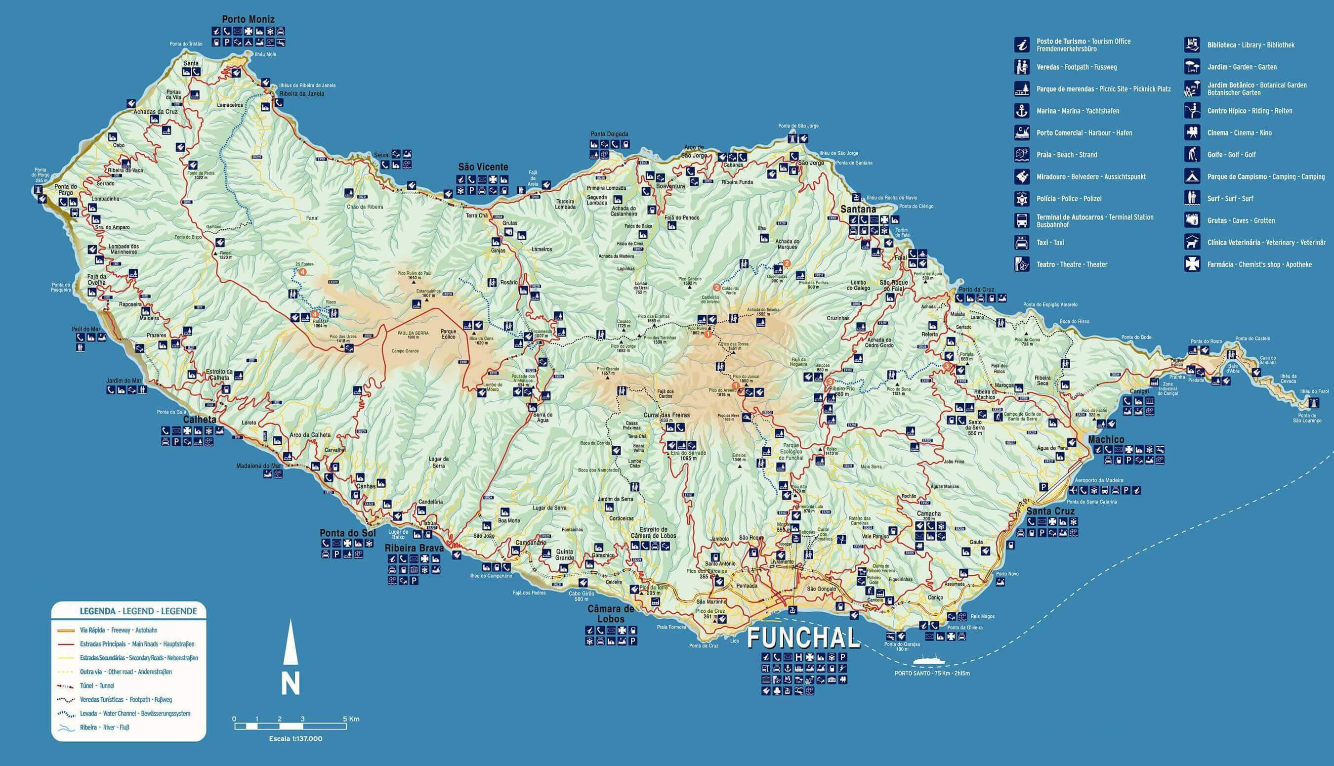 Tourist map Madeira
3030 x 1830, 415 KB
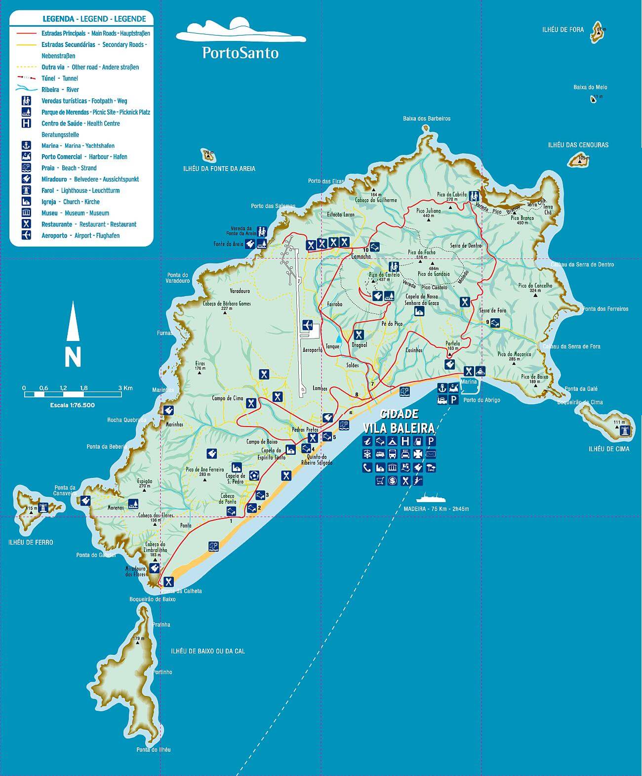 Tourist map Ihla de Porto Santo
1300 x 1570, 194 KB
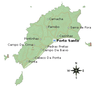
Ihla de Porto Santo
Porto Santo lies 43 km northeast of Madeira. Zarco and his crew took shelter here in 1418, while on their way to explore the west coast of Africa. Realizing that the island would be a useful base, he returned here in 1419 to plant the Portuguese flag, going on to Madeira the following year. Early settlers introduced rabbits and goats, which quickly stripped the island of its vegetation, so Porto Santo is not as green as Madeira. Instead, the “Golden Island” has one major asset: its magnificent sandy beach, which brings holiday makers from Madeira and mainland Europe in search of sunshine, sea and the agreeable sense of being a very long way from the busy world.
 On top of Porto Santo’s volcanic rocks, limestone, sandstone and coral were laid down millions of years ago, beneath a warm, shallow sea. Falling sea levels exposed the coral to erosion, and the result is the magnificent 10-km sweep of sand that runs along the southern side of the island. Backed by dunes and tamarisk trees, the beach is clean, wild and undeveloped, but bathers are never far from a beachside café. Enjoying the beach may have therapeutic benefits: burying yourself in the sand is said to bring relief from rheumatism and arthritis.
All life on the island centres on the capital, which sits roughly halfway along the southern coast. Pavement cafés fill the main square, Largo do Pelourinho (“Pillory Square”), where offenders were once punished and public proclamations read out. The town hall, with its double staircase flanked by dragon trees, now stands on the site of the pillory. The cobbled pavement in front has a glass-topped, stone-lined pit, which was once used for storing grain.
The palm-lined path leading from the centre of Vila Baleira to the seafront is flanked by landscaped gardens dotted with rusty cannons. There are also memorials to Columbus (a bust set on a ped-estal), to the 16th-century soldiers and sailors who colonized Madeira (an obelisk carved with abstract figures), and to the sailors who used to risk their lives crossing heavy seas to keep Porto Santo supplied with food and firewood (a bronze statue of a sailor at the rudder of a boat).
Weather forecast for Camacha | Ihla de Porto Santo
Funchal 73 km away
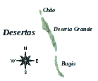
The Ilhas Desertas
Also part of the Madeiran archipelago is the arid and treeless Ilhas Desertas, which lies about 25 km to the southeast of Ponta de São Lourenço, the eastern tip of the island of Madeira.
 The three islands of the Desertas are,
listed from north to south:
Chão Islet
Deserta Grande
Bugio
Ponta de São Lourenço is linked underwater to the offshore Ilhas Desertas (“Desert Isles”), which form part of the same volcanic formation. Though arid and uninhabited, these islands nevertheless host all sorts of rare and endangered wildlife, including spiders, monk seals, petrels and shearwaters. An application has been made to UNESCO to have the islands declared a World Natural Heritage Site.
A tiny colony of Mediterranean Monk Seals inhabit the beaches, and since 1990 the islands have been a nature reserve for their protection. The only human presence are the permanent wardens, geologists, occasional boaters, and the few research stations on the islands
Exploring : For a closer look, contact one of the boat companies based at Funchal’s marina, many of which offer day-long trips to the islands. Administratively, the islands are part of the municipality of Santa Cruz, Madeira.
Madeira short brief guide
When to go : Christmas is peak season; hotels charge double their normal rates. Easter, July and August are also busy. June is surprisingly quiet, and enjoys perfect weather. Madeira has a generally mild subtropical climate, with average temperatures ranging from 17° C in February to 23° C in September. October to March sees the highest rainfall, especially on the northern side of the island. Porto Santo tends to be fine throughout the year.
What to pack : Even in winter it is warm enough to eat out of doors during the day, so you will need light clothes, with extra layers for nights and the cooler mountains. Casual wear is the norm. If you intend to walk, bring a torch, waterproofs and non-slip shoes.
Tourist offices : The Portuguese tourist office has branches in most countries, but offers only basic information on Madeira. The Madeira tourist board’s website is help-ful, but infrequently updated. Funchal’s main tourist office sells guides, maps, bus timetables and tickets for cultural events.
Passport and visa : Visitors can stay on Madeira for 90 days with a valid passport or recognized EU identity card and an onward or return ticket. There are no embassies on the island itself (they are all located in Lisbon). Several consulates are located in Funchal.
Time differences : Madeira observes exactly the same time as the UK, throughout the year.
Language : Most Madeirans can converse in English. Many can also manage common French and German phrases, in addition to their native Portuguese.
Customs : As part of the European Union, Madeira imposes virtually no restrictions on imports of cigarettes and alcohol from other EU member states, as long as they are for private consumption.


