

Setup & config options
Suitable power supply
RasPi & sFTP file transfer
Home network print server
Home network scan server
Mesh : home Lan USB drive
Explore hard & software
UFW firewall explained
Secured by fail2ban server
Software packaging & PPA
Apache 2.4+ LAMP server
https web server : port 443
Varnish caching proxy
Module : cgi & perl
Module : geoip
Modules : php & mysql
http*s error handling
Server : conditional logging
TL-domain & dynamic DNS
Webalizer log analyser
Defeat referrer spam
robots.txt & xml sitemaps
Server : .htaccess handling
The game & not the islands
Setup & config options
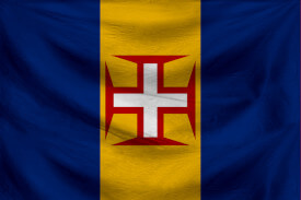
North Atlantic : Macaronésia
🚫 No ads & tracking
![]()
![]()
![]()
![]()
![]()
⌘ Around Madeira
An interesting snapshot on Madeira and Porto Santo.
The beaches and locations of interest. Outdoor activity.
This is an older article which I wrote on a free subdomain provided by Wordpress many years ago.
16-Jul 2018
⌘ Western Madeira | Overview
The locations
Ribeira Brava : Ribeira Brava is one of the island’s oldest towns, well established as a centre of sugar production by the 1440s. The large parish church has sculpture dating from the 1480s. At the other end of the village is the Museu Etnográfico da Madeira, with a small shop selling Madeiran crafts.
Boca da Encumeada : The Encumeada Pass is a saddle of rock forming the watershed between the north and south of the island. Clouds from the north often spill over the lip of the mountains, like dry ice pouring from a flask. Wherever you look, there are majestic peaks, from Pico Grande in the east to cone-shaped Crista de Galo in the west. Just south of the pass is the Levada do Norte (signposted “Folhadel”), which offers a lovely 15-minute walk to the point where it enters a tunnel.
São Vicente : This pretty village on the northern side of the Encumeada Pass demands to be captured in paint; deep-green shutters, doors and balconies, with stone lintels and frames of ox-blood red, are set in white-walled houses along the grey basalt streets.
Seixal : Most of the coastal road now runs through tunnels, but Seixal is one of the few places where you can still get a sense of the north coast’s visual splendour. Tall cliffs stretching into the distance are pounded by powerful waves that swell and break at their feet. Vineyards cling to the rock on almost vertical terraces. Waterfalls plunge from the wooded heights on either side of the village.
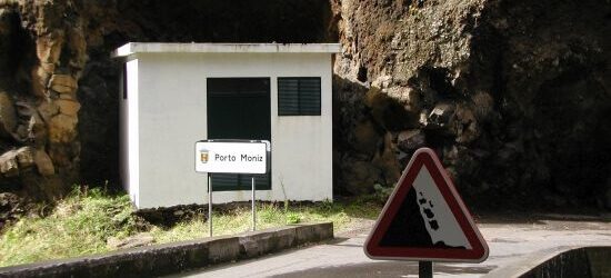
Porto Moniz : Porto Moniz, the most north-westerly conurbation on the island, combines a bustling agricultural town set high up around its church, with a lower town devoted to food and bathing. Natural rock pools have been turned into a bathing complex offering a safe environment in which to enjoy the exhilarating experience of being showered by spray from waves breaking on the offshore rocks. The newly landscaped seafront is lined with restaurants selling some of the island’s best seafood.
Jardim do Mar : This pretty village sits at the meeting-point of several ancient cobbled footpaths, which climb up the cliffs to either side. In the village itself, a maze of alleys winds down to a pebble beach, where surfing competitions are held during the winter months. A new seafront road and a large sea-wall were completed in 2004. Opinions vary as to how this has affected the quality of the surfing here.
Calheta : Calheta’s fine parish church, a scaled-down version of Funchal cathedral, stands on a terrace halfway up the hill leading west out of the village. It has a precious 16th-century ebony-and-silver tabernacle, and a richly decorated knotwork ceiling above the high altar. Next door to the church is the Engenho da Calheta, one of Madeira’s two surviving sugar mills; the other is in Porto da Cruz. As well as producing mel (honey), used in making the island’s unique bolo de mel (honey cake), the mill also makes aguardente (rum) from distilled cane syrup.
Paúl da Serra : The undulating plateau of Paúl da Serra is the gathering point for the waters that feed many of the island’s rivers and levadas . It serves as a sponge for the abundant rains which fall when clouds reach the island, rise, then cool. Free-range horned cattle graze the lush grass. People from the surrounding villages come here in summer to pick wild bilberries and blackberries, which they turn into delicious conserves. Many of them also depend on the plateau’s forest of wind turbines to supply them with electricity.
Ponta do Pargo : Madeira’s westernmost point, Ponta do Pargo is the best place on the island to watch the setting sun or to gaze down at the waves breaking along the tall cliffs of the island’s southern and western coasts. The lighthouse on the headland (built in 1896) has a small exhibition of maps and photographs charting the history of lighthouses on every island in the Madeiran archipelago. The ceiling of the parish church is covered with colourful paintings of sunsets, terraced hills, and the scenic spots of the western part of the island, all painted in the 1990s by a Belgian artist who has settled in the village.
Rabaçal : Washed by centuries of rain running from the flat, monotonous surface of the Paúl da Serra, Rabaçal is a magical green cleft in the moorland. A brisk 2-km walk down a winding tarmac path takes you through stands of heather and broom to a forest house with picnic tables. Rabaçal marks the start of two popular walks. One follows the Levada do Risco to the Risco Waterfall; the other follows the next terrace down to 25 Fontes, a cauldron-like pool fed by numerous cascades.
Ribeira da Janela : This wild, uninhabited valley 18 km long, joins the sea beside a rocky islet with a window-like hole. The road descends through a misty world of ancient trees kept moist by the condensation of clouds.
Fanal : This forest house halfway up the Ribeira de Janela is the starting point for walks that lead through an alpine landscape of herb-rich meadows, filled with ancient laurel trees.
Ponta do Sol : The American novelist John dos Passos (1896–1970) visited this sun-trap village in 1960 to see his grandparents’ house - now being turned into a cultural centre.
Lombada : On a ridge above Ponta do Sol is one of Madeira’s oldest houses - the 15th-century mansion of Columbus’s friend João Esmeraldo (see p65) . The watermill opposite is fed by one of the island’s oldest levadas . A pretty church of 1722 is lined with tile pictures of the Virtues.
Arco da Calheta : Another early church survives at the heart of this sprawling vil -lage - the mid-15th-century Capela do Loreto, founded by the wife of Zarco’s grandson.
Lombo dos Reis : The “Ridge of the Kings” is named after the tiny, rustic Capela dos Reis Magos, which has a rare early 16th-century Flemish altar carving of the Nativity.
Lugar de Baixo : Above the tiny freshwater lagoon at Lugar de Baixo is a visitor centre with pictures of the wild birds that frequent this rocky shore, though you are more likely to see domesticated ducks and moorhens.
Prazeres : The priest at Prazeres has established a small children’s farm opposite the church, but the main attraction is the flowerlined path along the Levada Nova, which can be followed east or west.
Paúl do Mar : The best approach to this fishing and surfing village is down the twisting road from Fajã de Orvela. On the way, look out for a glimpse of the stunning Galinas Gorge.
Cristo Rei : This statue of Christ is reminiscent of the famous one in Rio de Janeiro. It is also the starting point for easy levada walks - west to the Paúl da Serra, east to the waterfalls at Cascalho.
⌘ Eastern Madeira | Overview
The locations
Garajau : A miniature version of Rio de Janeiro’s statue of Christ the Redeemer was erected on the wild and rocky headland at the southern end of the village in 1927. The terns ( garajau in Portuguese) that gave their name to the village can still be seen from the zigzag path that winds down the cliff face to a pebble beach below the headland. Underwater caves and reefs rich in marine life extend for 2 km to either side, and are protected as a marine reserve.
Caniço de Baixo : Along Rua Baden Powell, the main street of this clifftop holiday village, you will find Inn and Art, a charming villa hotel that mounts exhibitions of modern art. The tiny Praia da Canavieira public beach is reached down an easily-missed alley near the junction with Rua da Falésia. For a small sum you can also use the Galomar Lido. The lido is the base for the Manta Diving Centre, which organizes trips to the Garajau Marine Reserve.
Santa Cruz : Santa Cruz is a town of great character, and surprisingly peaceful, given that the airport runway is right next door. The focal point is the beach, lined with cafés and pastelarias, as well as the Art Deco-style Palm Beach Lido, painted azure and cream. Back from the coast and down winding alleys is a 15th-century Gothic church as splendid as the cathedral in Funchal, and perhaps designed by the same architect.
Machico : Machico is where Captain Zarco and his crew first set foot on Madeira in 1420. The chapel they founded is on the eastern side of the harbour, shaded by giant Indian fig trees. A statue of Machico’s first gover-nor, Tristão Vaz Teixeira, stands in front of the fine 15th-century parish church on the main square. A grid of cobbled alleys leads from here down to the seafront fortress.
Caniçal : Caniçal holds the dubious honour of being a former whaling port. In 1956, John Huston came here to shoot the opening scenes of Moby Dick , but its star, Gregory Peck, became so seasick that they had to shoot the rest in a studio. The Museu da Baleia explains how conservation has replaced whaling. Tuna fishing now plays a vital role in the local economy.
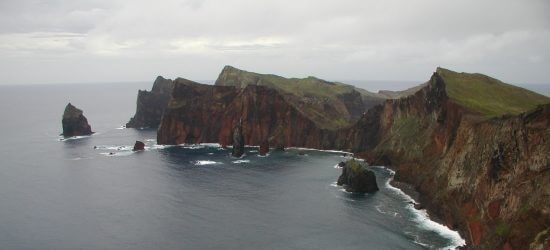
Ponta de São Lourenço : The long, narrow chain of eroded volcanic cliffs and ravines at the eastern tip of Madeira is an exciting and dramatic wilderness, protected as a nature reserve because of its coastal plants. The rocky peninsula can be explored from the much-used path that starts from the car park located at the end of the south coast road.
Portela : The viewing point at Portela has more than its fair share of roadside cafés because it was once the transport hub for the east of the island. New tunnels linking São Roque do Faial with Machico have changed all that, but Portela is still an important landmark for walkers. You can walk south from here to Porto da Cruz along a trail once used by wine carriers, or west along the Levada do Portela through dense primeval wood -land and mountain scenery to Ribeiro Frio.
Santo António da Serra : The village of Santo António da Serra (known to Madeirans simply as Santo da Serra), sits in the middle of a plateau flat enough for golf courses and fields of grazing cows. Despite its frequent cloud cover, wealthy English merchants once built rural homes here: one of the former homes of the Blandy family is now a public park with camellias, hydrangeas and rhododendrons, and viewing points that look out toward Ponta de São Lourenço.
Camacha : A monument in the centre of Camacha proudly declares that Portugal’s first ever game of football was played in the town in 1875, organized by an English schoolboy. However, it is the O Relógio wicker factory opposite that draws people here, rather than its soccer history. You can see demonstrations of wicker-making in the workshop. If you explore the back streets of the village, you can spot the raw material: stacks of freshly cut willow canes. These are steeped in water and stripped of their bark, before being boiled to make them pliable enough to weave.
⌘ Central Madeira | Overview
The locations
Monte : Take the cable car from Funchal’s Zona Velha up to Monte, and you will sail 600 m up the southern face of Madeira to a place that seems more garden than village, shaded by veteran trees and watered by natural springs.
Quinta do Palheiro Ferreiro : Thanks to a period spent in exile in England during the early 19th century, the first owner of this estate, the Count of Carvalhal, developed a love of meadows, woods and streams, and laid the foundations for today’s richly varied garden.
Câmara de Lobos : The lobos (“wolves”) in the name of this pretty village refer to the monk seals that once basked on the pebbly beach. This is now used as an open-air boatyard, where traditional craft are repaired or given a fresh coat of blue, red and yellow paint, laid on in bold stripes. Down among the noisy bars is the Fishermen’s Chapel, where villagers give thanks for the safe return of their men after a long night at sea, fishing for espada (scabbard fish), most of which ends up on the tables of Madeira’s many restaurants.
Curral das Freiras : A new road-tunnel now links the valley village of Curral das Freiras with the wider world, but for breathtaking views, travel along the old road via Eira do Serrado. By taking this route, you will also gain a sense of just how isolated this community once was.
Santana : Santana has Madeira’s best examples of the traditional timber-and-thatch dwellings known as palheiros. These brightly-painted triangular houses are comforable but compact, and many now have modern extensions to accommodate the kitchens and bathrooms that the originals lacked. You can visit and take photographs of a row of tourist-board houses next to the church, but wander the lanes of the village and you will see plenty more, with immaculate gardens.
Jardim Botânico : Come here to satisfy your curiosity about the names and origins of all the flowering trees, palms, succulents and scented climbers that grow everywhere in Madeira - in front gardens, in public parks and along country roads.
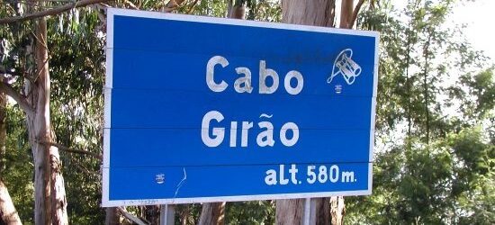
Cabo Girão : Madeira’s highest sea cliff, 580 m above the ocean, also claims to be the second highest in the world, but opinions differ over the location of the highest. From the viewing point perched on the summit, you gaze down to a fajã, a rock platform created when part of the cliff face fell into the sea millennia ago. Local farmers cultivate crops here in neat terraces. If you want a closer look, you can take the cable car from Caldeira Rancho, on the western side of Câmara de Lobos, down to the base of the cliff.
Ribeiro Frio : The “Cold River” of this valley clearing tumbles down the mountainside to bring clear water to a trout farm set in a pretty garden planted with Madeira’s native flowers.
Pico do Arieiro : In the colourful landscape of Madeira’s third highest peak you can read the story of the volcanic forces that created the island, and the elemental battles between wind, rock and rain that eroded it into jagged peaks and plunging ravines.
Pico Ruivo : Madeira’s highest peak is reached from the road next to the petrol station on the eastern side of Santana. This leads to the car park at Achada do Teixeira, from where a well-paved path climbs to the summit (1,862 m). To the south, the views look over the high peaks and jagged ridges of an arid volcanic landscape; to the north, clouds hang around the lush, forested slopes. Back at the car park, look for the eroded rocks called Homem em Pé (“Standing Man”) in a hollow behind the rest house.
Terreiro da Luta : Pious Madeirans believe that the Virgin appeared to a young shepherd girl on this spot and gave her the statue now in Monte church. The present memorial was erected after Ger-man U-boats attacked ships in Funchal Harbour in 1916; the Virgin’s help was sought and the bombardment stopped.
Queimadas : From western Santana, a road signposted to “Queimadas” gives way to a track leading to a house with gardens, ponds and picnic tables deep in the green-wooded heart of the UNESCO World Natural Heritage forest.
Caldeirão Verde : From Queimadas, take a scenic levada walk to the “Green Cauldron”, a waterfall cascading down a rock hollow. Sturdy footwear, torches and waterproofs essential.
Ponta Delgada : At Ponta Delgada’s church, see the miraculous statue, found floating at sea in the 16th century. When the church burned down in 1908, it was found charred but intact in the embers.
Boaventura : Boaventura makes a great base for exploring the orchards watered by the Levada de Cima.
São Jorge : São Jorge has a Baroque church from 1761. A 19th-century lighthouse sits on Ponta de São Jorge, with views of the coast. A side road east of the village leads to a small, sheltered beach.
Faial : The Fortím do Faial is a toy-town fort built in the 18th century to fend off pirates. South of the village are views of Penha de Águia and the newly formed rock platform (fajã) where part of the cliff fell into the sea.
Penha de Águia : “Eagle Rock” rises 590 m from the sea, casting its shadow over neighbouring villages. Young Madeirans regard the climb from Penha de Águia de Baixo to the top as a test of strength and endurance.
São Roque de Faial : Several valleys meet at São Roque, so walkers can start at the church and choose one of the paths that go west up the Ribeiro Frio or east up the Tem te Não Caias.
Porto da Cruz : The Old Town is a maze of cobbled alleys and old wine warehouses. A sugar mill stands by the harbour, where visitors can buy the aged, locally distilled spirit aguardente.
⌘ Madeira | The beaches
Praia Formosa : Steep-sided Madeira does not have many beaches – cliffs and rocky shores are the norm – so Praia Formosa (“Beautiful Beach”), a stretch of grey, sea-smoothed pebbles between Funchal and Câmara de Lobos, is a notable exception. Madeira’s government has begun to realize what an asset this could be; it has plans to landscape the area around the beach and remove the unsightly oil depots.
Ponta do Sol : The beach at Ponta do Sol (“Sun Point”) is the perfect place to watch the setting sun. Dramatic clouds float like islands in a pink and purple sky.
Jardim do Mar : In October, the narrow strip of west-facing rocky beach connecting Jardim do Mar and Paúl do Mar is the point from which surfers gain access to the waves. Surfers need to bring their own equipment as there are no rental facilities.
Câmara de Lobos : Madeira’s most photogenic beach was put on the map when Winston Churchill, the famous British wartime prime minister, set up his easel here in 1949. Churchill was an accomplished artist, with an eye for a wellcomposed scene. Nearly 60 years later, that scene has not changed: colourfully striped fishing boats are still lined up on the cobbles of the little beach for cleaning and repair.
Porto Moniz : Thundering waves dash Madeira’s northern shores along the dramatic north coast road to Porto Moniz, but once there you can relax in the sun-warmed water of natural rock pools, and let those same waves shower you with spray.
São Jorge : About 2 km east of São Jorge, a sign to Praia (“Beach”) directs you to the estuary of the São Jorge river, where you can either swim in a natural pool in the bend of the river or, if you prefer, in the sea (access is from the small pebbled beach). There’s a beach café selling drinks and snacks.
Prainha : A pretty, sheltered bay with a beachside café at its eastern end, Prainha has Madeira’s only naturally sandy beach. Calheta, on the south coast, now also has a sandy beach – created with sand imported from Morocco.
Garajau and Caniço : A path from the statue of Christ the Redeemer at Garajau winds down to a beach popular for snorkelling and diving. It marks the start of a marine reserve with underwater caves leading to Caniço de Baixo, which can also be reached from the Lido at the Hotel Galomar.
Praia dos Reis Magos : Continuing eastward from Caniço de Baixo, a new seafront promenade leads to Praia dos Reis Magos, a rocky beach with a scatter of fishermen’s huts and a couple of simple cafés selling freshly grilled fish – idyllic for crowd-shy romantics.
Porto Santo : If a holiday is incomplete for beach, then take a ferry or a flight to Porto Santo, 40 km north-east of Madeira, where you can enjoy a 10-km stretch of unspoilt golden sand.
⌘ Madeira | Outdoor activity
Grutas de São Vincente : These caves were created by molten rock. A cave tour, simulated eruptions and a short film will teach you about Madeira’s volcanic origins. São Vicente, Sítio do Pé do Passo.
Homem em pé : There is something magical about emerging from the sun and looking across the peaks of Funchal from the Pico do Arieiro, Madeira’s third highest peak at 1,810 m. The 5-km round trip on foot to the top of Pico Ruivo, Madeira’s highest peak at 1,862 m is within the capacity of fit children over the age of ten. Back at the car park, look for the eroded rocks called Homem em pé (“Standing Man”) in a hollow behind the rest house.
Cabo Girão : Madeira’s highest sea cliff, 580 m above the ocean, also claims to be the second highest in the world, but opinions differ over the location of the highest: some say Norway, others the Orkneys or Ireland. From the viewing point perched on the summit, you gaze down to a fajã , a rock platform created when part of the cliff face fell into the sea millennia ago. Local farmers cultivate crops here in neat terraces. If you want a clos -er look, you can take the cable car (teleférico) from Caldeira Rancho, on the western side of Câmara de Lobos, down to the base of the cliff.
Ponta de São Lourenço : The long, narrow chain of eroded volcanic cliffs and ravines at the eastern tip of Madeira is an exciting and dramatic wilderness, protected as a nature reserve because of its coastal plants. The rocky peninsula can be explored from the much-used path that starts from the car park located at the end of the south coast road.
Parrot park : Depending on the age of your children, you can either let them enjoy the playful antics of parrots and parakeets, or engage them in a discussion about the ethics of keeping wild creatures in cages for human amusement. While you’re here, you can also explore the Botanical Garden.
Jardim Botânico, Funchal : As well as being a place where avid plant lovers can learn all about the astonishing range of plants that thrive in Madeira’s warm and humid climate, this is also a great spot just to relax and enjoy the visual richness of the immaculately maintained flower beds. The gardens occupy the grounds of an estate that once belonged to the Reid family (founders of the world-renowned Reid’s Palace Hotel) and, with a practised eye for a good building site, they chose to build their mansion on a sunny slope blessed with panoramic views.
Monte cable car : Take the cable car from Funchal’s Zona Velha up to Monte, and you will sail 600 m up the southern face of Madeira to a place that seems more garden than village, shaded by veteran trees and watered by natural springs.
Football : Madeira has two soccer teams, Maritimo and Nacional; both play in the Portuguese League. Home matches are friendly, family occasions. Maritimo: Estádio dos Barreios, Rua do Dr Pita, Funchal. Nacional: Choupana Stadium.
Boat trips : Booths located around Funchal’s marina have details of all the cruising options available, from day-long trips to Ilhas Desertas and half-day whale-and dolphin-watching tours, to shorter sunset cruises. There are lots of boat trips to choose from, but younger children will particularly enjoy a trip on a replica of the Santa Maria, the ship that took Columbus across the Atlantic. Marina do Funchal.
Deep-sea fishing : Fishing trips can be booked around the marina. A tag-and-release policy ensures fish are released into the wild once caught. Funchal Marina.
Walking : With more than 1,700 km of rural footpaths to choose from, it’s no wonder that thousands of people visit every year just to walk in the island’s mountains and forests. See also below : Levada Walking.
Diving : Clean Atlantic waters, clear visibility and an array of beautiful fish and reefs make Madeira a popular spot for divers of all ages and abilities.
Adventure sports : Madeira’s challenging countryside lends itself to all sorts of adventure sports, from rock-climbing to hang-gliding, but few companies yet exist to provide organized excursions. One that does is Terras de Aventura, offering mountain biking, jeep safaris, off-road biking, climbing, kayaking, canyoning and paragliding.
Horse riding : The Associação Hípica da Madeira can provide lessons for beginners; for more experienced riders there are guided tours along Madeira’s beautiful, narrow mountain tracks and hidden forest byways. Quinta Vila Alpires, Camhino dos Pretos, São João de Latrão.
⌘ Madeira | Levada walking
Facts about levada walking
What are levadas : The word levada means “to take”. A levada is an irrigation channel, designed to take water from places where it is plentiful to those where it is not. The Madeirans borrowed the idea from the mountains of Andalucia, where the channels are known as acequias.
Why levadas were built : Water is abundant in the mountains to the north of the island, but scarce in the fertile and sunny south, where most crops are grown. Looking for a way to store water and carry it to their cultivation terraces and fields, the island’s early settlers began to build the irrigation channels that form the basis of today’s network.
Water and power : Water was essential to the growth of Madeira. It irrigated the wheat, sugar, grape and banana crops, powered the sawmills used to turn trees into timber for construction and ship-building, and turned the wheels of the mills that crushed sugar.
Levada maintenance : Levadas require constant maintenance to remove rockfalls and vegetation that could block the flow of water. Paths were constructed alongside the chan-nels to allow the levadeiro, or maintenance man, to patrol his length of levada and keep it in good working order.
Levadas as footpaths : The Levada maintenance paths made perfect footpaths – many of which provide the visitor with easy walking routes, with spectacular views. A resulting guide book, Landscapes of Madeira, has brought thousands of walkers to the island.
Construction : Constructing levadas was a feat of engineering. Following the contours meant digging channels into the face of sheer cliffs, or building aqueducts over deep crevices. To reach inaccessible spots, levada builders were lowered down cliffs in baskets.
Contour lines : To prevent the water from running too fast, causing soil erosion, most levadas follow the contours of the landscape, winding in and out of valleys, descending gradually from the high peaks of the island’s central massif to the ridges and terraces
Guided tours : Levada walking is easiest if you join a guided tour. Madeira Explorers and Nature Meetings are good companies; the tourist board will have details of others.

⌘ Ilha de Porto Santo | Overview
The locations
Vila Baleira : All life on the island centres on the capital, which sits roughly halfway along the southern coast. Pavement cafés fill the main square, Largo do Pelourinho (“Pillory Square”), where offenders were once punished and public proclamations read out. The town hall, with its double staircase flanked by dragon trees, now stands on the site of the pillory. The cobbled pavement in front has a glass-topped, stone-lined pit, which was once used for storing grain.
Nossa Senhora da Piedade : To the east of the main square in Vila Baleira stands the majestic par -ish church, Nossa Sen -hora da Piedade, completed in 1446. Gothic rib-vaulting and rainwater spouts carved with human and animal heads have survived from this earlier church, which was torched by pirates, then rebuilt in 1667. The 17th-century altar painting of Christ being laid in his tomb is by Martím Conrado. The saints on either side were painted in 1945 by German artist Max Romer.
Casa Museu Cristóvão Colombo : Christopher Columbus (1451–1506) came to Madeira in 1478 as the agent for a Lisbon sugar merchant. Here he met and married Filipa Moniz, daughter of the governor of Porto Santo. Their son was born in 1479, but Filipa died soon after the birth, and Columbus left the islands in 1480. The house where he and Filipa are said to have lived is now a museum, displaying portraits of Columbus, maps of his voyages and models of his vessels.
Pico de Ana Ferreira : Porto Santo consists of a saddle of land between two groups of cone-shaped volcanic peaks. At 283 m, the Pico de Ana Ferreira is the highest of the summits at the more developed western end of the island. A road up its southern slopes will take you as far as the 17th-century Church of São Pedro. From there, a track leads around the peak to a disused quarry featuring an interesting formation of prismatic basalt columns aptly known as the “Organ Pipes”.
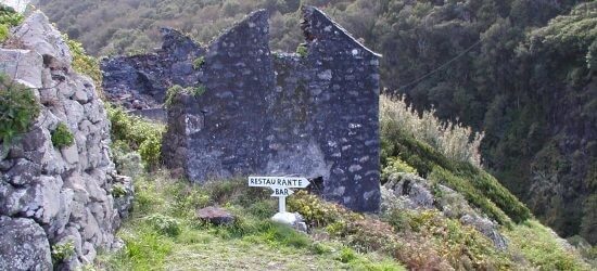
Ponta da Calheta : The westernmost tip of the island is a beautiful spot, with a series of secluded sandy coves reached by scrambling over wave-eroded rocks. From the bar and restaurant at the end of the coast road, you can look across to Ilhéu de Baixo, the large, uninhabited rocky islet south-west of Porto Santo. Madeira, too, is visible on the distant horizon, resembling a huge whale, and usually capped by clouds.
Zimbralinho : Zimbralinho is the most beautiful of all the little rocky coves nestling along the western flank of the island, its transparent blue seas popular with swimmers and divers. The cove is at its best around lunchtime, as it is shaded earlier and later in the day. The path to the cove starts at the end of the road that leads to the Centro Hipico, at the western end of the island.
Fonte da Areia : Water once bubbled straight out of the sandstone cliffs at Fonte da Areia (“Fountain of Sand”), but in 1843 the spring was tamed, and you can now taste the natural, rock-filtered mineral water by simply turning a tap. The path to the spring leads down a wind-eroded gully, where the cliffs have been sculpted into laminated sheets of harder and softer rock. Lovers have carved their names on the rock face, but so ferocious is the scouring wind that declarations of perpetual love inscribed 10 years ago are now growing faint.
Pico do Castelo : The high peak to the east of Vila Baleira is called Castle Peak, though despite its name, it was never fortified. From the 15th century on it was used as a place of refuge whenever pirates threatened to attack. It was equipped with a cannon, which still survives at the lookout point near the summit. A cobbled road takes you all the way to the lookout, past the cypress, cedar and pine trees that have been planted to turn the slopes from sandy to green.
⌘ The beaches
The beach : On top of Porto Santo’s volcanic rocks, limestone, sandstone and coral were laid down millions of years ago, beneath a warm, shallow sea. Falling sea levels exposed the coral to erosion, and the result is the magnificent 10-km sweep of sand that runs along the southern side of the island. Backed by dunes and tamarisk trees, the beach is clean, wild and undeveloped, but bathers are never far from a beachside café. Enjoying the beach may have therapeutic benefits: burying yourself in the sand is said to bring relief from rheumatism and arthritis.
The seafront : The palm-lined path leading from the centre of Vila Baleira to the seafront is flanked by landscaped gardens dotted with rusty cannons. There are also memorials to Columbus (a bust set on a ped-estal), to the 16th-century soldiers and sailors who colonized Madeira (an obelisk carved with abstract figures), and to the sailors who used to risk their lives crossing heavy seas to keep Porto Santo supplied with food and firewood (a bronze statue of a sailor at the rudder of a boat).
⌘ Outdoor activity
Diving : Thanks to unpolluted seas and the absence of commercial fishing, Porto Santo’s shores are rich in marine life. See for yourself with Porto Santo Sub, based at the marina.
Beachcombing : Take a leisurely stroll along the unbroken sands from Vila Baleira to Ponta da Calheta. Tropical shells and the occasional bean-shaped seed (known as “Columbus Beans”, because they are said to have inspired the explorer to look for land on the other side of the Atlantic) often wash up on the shore.
Horse riding : Porto Santo’s newly opened Centro Hípico (Equestrian Centre) takes beginners, and is located at Ponta, at the western end of the island. Location: Centro Hipico, Ponta.
Exploring : Taxis offer reasonably priced island tours, but if you prefer to explore independently, you can hire a car for the day or rent out bicycles and scooters.


