Setup & config options
Suitable power supply
RasPi & sFTP file transfer
Home network print server
Home network scan server
Mesh : home Lan USB drive
Explore hard & software
UFW firewall explained
Secured by fail2ban server
Software packaging & PPA
Apache 2.4+ LAMP server
https web server : port 443
Varnish caching proxy
Module : cgi & perl
Module : geoip
Modules : php & mysql
http*s error handling
Server : conditional logging
TL-domain & dynamic DNS
Webalizer log analyser
Defeat referrer spam
robots.txt & xml sitemaps
Server : .htaccess handling
The game & not the islands
Setup & config options
North Atlantic : Macaronésia
🚫 No ads & tracking
![]()
![]()
![]()
![]()
![]()
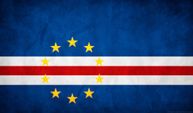
Cape Verde - portuguese Cabo Verde
The ample information about the Cape Verde - Cabo Verde - islands
This is an older article which I wrote on a free subdomain provided by Wordpress many years ago.
10-Dec 2018
Cape Verde - portuguese Cabo Verde - is a group of 10 islands (9 are inhabited) located in Western Africa, in the North Atlantic Ocean, west of Senegal. The climate is temperate. The lands are steep, rocky and volcanic. Seasonal hurricanes. Volcanic and seismically active. Endemic species of birds and reptiles endangered by human development.
The culture has been influenced by the Portuguese and African cultures. Most popular sport is soccer. It is a tradition for friends to walk around the praça (town square). The music is influenced by Portuguese, caribbean, African and Brazilian beats. The national music is called morna. Dances include morna, passada (Zouk), Funaná, coladeira and the Batuque. Rich literature. Diet mostly based on fish, corn, rice, vegetables and fruits
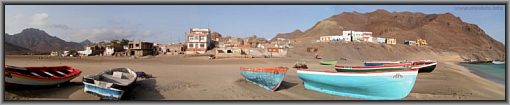
The people are some of the friendliest in the world and although the food may not be to everyone's taste, the local culinary delights are worth trying. All islands have their own personalities and anyone going to Cape Verde should try to visit the main islands of Santiago, Sao Vicente and Boa Visa.
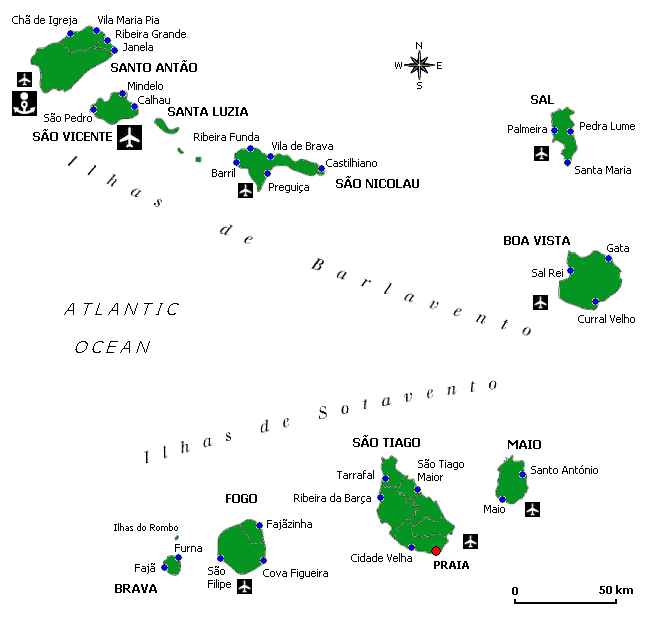
The overview map - islands
Ilhas de Barlavento: Santo Antão, São Vicente, Santa Luzia, São Nicolau, Sal, Boa Vista.
Ilhas de Sotavento: Maio, São Tiago, Fogo, Brava.
The facts on history
When Portuguese mariners discovered Cape Verde in 1456, the islands were uninhabited but fertile enough to attract the first group of settlers six years later. They founded Ribeira Grande (now Cidade Velha), the first European town in the tropics, on the island São Vicente. To work the land, settlers almost immediately began to import slaves from the West African coast. Plans by Genoese investors to create large sugar plantations never paid off, especially after the Caribbean proved so productive.
However, the islands’ remote yet strategic position made them a perfect clearinghouse and victualling station for the transatlantic slave trade. Within a century, the islands had grown wealthy enough to attract pirates, including a 1585 raid by England’s Sir Francis Drake.
In 1747, changing weather patterns, aggravated by deforestation and overgrazing, resulted in Cape Verde’s first recorded drought.
In the 100 years from 1773, three droughts killed some 100,000 people – more than 40% of the population each time. It was only the beginning of a cycle that lasted well into the 20th century. At the same time, the island’s economic clout fell as Britain, France and the Netherlands challenged Portugal’s control over the slave trade. As a result, Lisbon invested little in Cape Verde during the good times and offered almost no help during bad times. To escape hunger, many men left the islands, principally to work as hired hands on American whaling ships. Even today, Cape Verdean communities along the New England coast rival the population of Cape Verde itself, and foreign remittances account for as much as 20% of GNP.
Cape Verde’s fortunes revived with the advent of the ocean liner at the end of the 19th century.
The climate
Cape Verde is pleasant year-round. Even during the so-called rainy season from mid-August to mid-October, weeks can go by without a downpour. Thanks to cooling ocean currents and offshore winds, Cape Verde has the lowest temperatures of any country in West Africa, and also some of the most moderate, ranging from a minimum night-time average of 19C in February to a maximum daytime average of 29C from May to November.
Summer temperatures, especially in the northern islands, can be cooler than in Europe, though the southern islands, especially Fogo, can get hot and sticky. From December to March you may need a sweater in the evenings, especially at higher altitudes. Winter months are also marked by gusty winds, which blow in dust all the way from the Sahara.
Weather forecast for Sal Rei, Boa Vista island | Cape Verde
Weather forecast for Praia Santiago island | Cape Verde
Weather forecast for Sal island | Cape Verde
🚌 Getting there
Seven of the nine islands offer internal flights: Sal, Santiago are the main internal and international hubs. San Vincente, Fogo, Boa Vista, San Nicolau and Maio are also accessed by air travel between the islands. With regular flights by day and night between Sal, Sao Tiago and Sao Vincente.
Transport
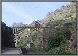
There is one reliable ferry service running between San Vincente and Santo Antao and a twice weekly ferry linking Sao Vicente, Santo Antao, Sao Nicolao and Sao Tiago. Aluguer: A locally run mini-bus or pick-up truck – a great way to meet the locals as you drive through spectacular scenery. Car Hire: Available on most islands, but beware the roads are at best rough and more commonly little more than a dirt track.
POI, locations of interest
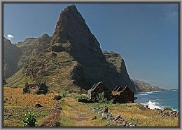
Santo Antão : Mountainous, rugged, spectacular, breathtaking ... tourists rave about the beauty, but the island is more for hikers than beach loungers. There is some local agricultural production, including traditional rum.
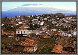
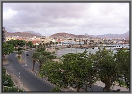
São Vicente : With some 80,000 inhabitants, who live mainly in and around Mindelo, Cape Verde’s best port, São Vicente is the country’s second-most populous island. When the archipelago was a hub for Atlantic shipping, it was largely centered on Mindelo. There is some manufacturing - clothing, footwear, and canned fish for export - and the government is promoting an industrial zone at Lazareto. The islan d is good for sports, principally windsurfing, cycling, hiking, horseback riding, and golf, and popular culture. Cape Verde’s best-known singer Césaria Evora is from here.
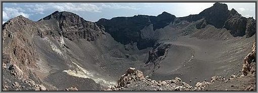
Fogo : A one-word tourist guide: “volcano.” Also “big” and “periodically active.” ast eruption: 1995. Nevertheless, more than 50,000 people live on Fogo; there is good farming land and the island produces sought-after cheese, coffee, and wine. Rain can be torrential but it runs off, leaving the land parched, so one Cape Verde politician has a plan to irrigate the fertile slopes with dams and pipelines, powered by alternative energy.
Brava : The smallest inhabited island in Cape Verde, Brava used to be a thriving whaling center, with ships from Europe and America dropping by. Interestingly, this led to an early Cape Verdean diaspora to the United States, as people hitched rides west on returning whalers, many settling in New England. Another claim to fame is as the birthplace of Eugénio Tavares (1867-1930), the country’s most famo us poet. Perhaps the key factor about Brava, apart from frequent earthquakes, is its intimidating neighbor: Brava lies just 10 kilometres downwind of Fogo, which is rather close for a major, active volcano.
Sal : Probably the best known of the Cape Verde islands, at least for sun worshippers flying in to the international airport from Europe – there’s virtually year-round sunshine. Just over 20,000 people live on Sal, and tourism is by far the principal activity. Modern tourism developments abound, particularly at the former fishing town of Santa Maria. From just over 1,000 in 1990, the local population now hovers close to 20,000. But the island’s tourist economy took a heavy hit during the crisis.
Santa Luzia : This small island is tucked between São Vicente and São Nicolau. People used to live here more than 200 years ago, but they ruined the soil. The population is now officially zero, although rumor has it that a lone shepherd still roams the island with his flock of sheep.
São Nicolau : This small, somewhat economically depressed island is beautiful and as yet without major tourism development. Great for bird watching and deep-sea fishing - the blue marlin is a favourite target. And of course hiking and cycling.
Boa Vista : The third largest island, but home to just 6,000 people - the land is poor, usually consisting of desert, and the population was declining before modern tourism worked its miracle. Now there are several developments capped by a 750-room international hotel, and even more planned. The largest city is Sal Rei - literally ‘Salt King’ - harking back to the island’s glory days as a salt producer. Boavista is known for marine turtles and traditional music.
São Tiago : The largest and most populous of the 10 islands, with roughly a quarter of Cape Verde’s total land area and half of the total population. Some 120,000 people, roughly half the island’s population, live in Praia (the name means ‘Beach’), which is the country’s capital. Just a few kilometres along the coast is Cidade Velha, or “Old City.” This used to be the capital until people there got fed up with constant pirate attacks. Today Cidade Velha is a World Heritage Site. The UNESCO citation notes it was the first European colonial town to be built in the tropics, and marks a decisive step in European expansion at the end of the 15-th century towards Africa and the Atlantic area.
Maio : Quite a poor island with large salt flats, but with some remaining forest, and good traditional farm produce, in particular cheese. The island has spectacular beaches and r ugged desert scenery, so there’s potential for eco-tourism. The government has set up an agency to promote sustainable tourism, and projects are starting to appear.